Dimensional Control
Dimensional Control / Terrestrial Laser Scanning
Dimensional Control
Our Dimensional Control / Terrestrial Laser Scanning Division complements our subsea LiDAR laser Technology Division by strategically placing subsea LiDAR laser scan targets on all applicable subsea assets that will subsequently be laser scanned subsea upon the assets being installed on the seafloor. These targets will be observed using a highly accurate total station in conjunction with an instrument-independent, traceable 3D graphical software which allows “real-time” data sets and field reporting. The measured coordinates of the subsea LiDAR targets will be utilized in the registration process of the point cloud datasets captured by the subsea LiDAR laser system.
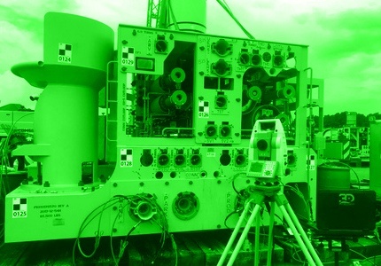
By utilizing our onshore Dimensional Control / Terrestrial Laser Scanning methodologies, we are able to minimize downtime during the fabrication / fit up process, mitigate out of tolerance conditions and fast track reports or other applicable deliverables to our clients. This is all made possible by our ability to capture highly accurate “real-time” observations/results/reports in the field using highly accurate, well maintained and calibrated instruments and tools along with powerful analytical metrology software. We have the ability to analyze, compare and report field measurement deviation values with respect to theoretical /design tolerances by mathematically aligning our instruments to the 3D design model provided by our client either in “real time” in the field while the measurements are being observed or at a later time.
Additional Dimensional Control / Terrestrial Laser Scanning services by our company include all aspects associated with industrial measurement, fabrication (all industries not limited to Energy sector), jumper fabrication and as-built, piping, precision alignments, vessel calibrations /offset surveys, drill rig dolly track alignment and component installation, third-party as-builts, and laser scanning which includes providing registered point cloud data to partial or complete 3D modelling deliverables.